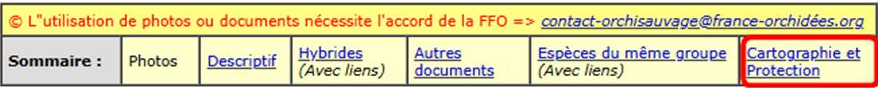
Species fact sheets on Orchisauvage now include direct access to distribution and conservation maps from the FFO Atlas website, which currently integrates all records available to the FFO: 1.6 million Orchisauvage records and 2 million additional records from other sources.
These maps are available at the bottom of each species page and can also be accessed directly from the table of contents at the top of the page.
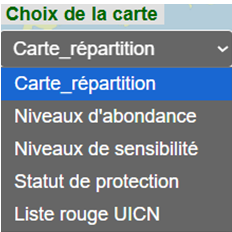
Using the drop-down menu, you can explore five different types of maps, each with interactive tooltips providing information on grid cells or departments.
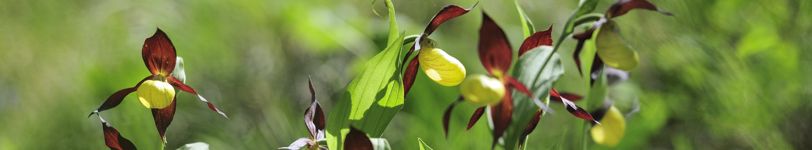
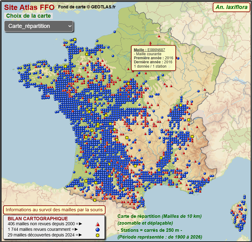
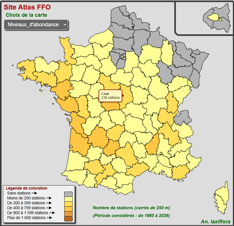
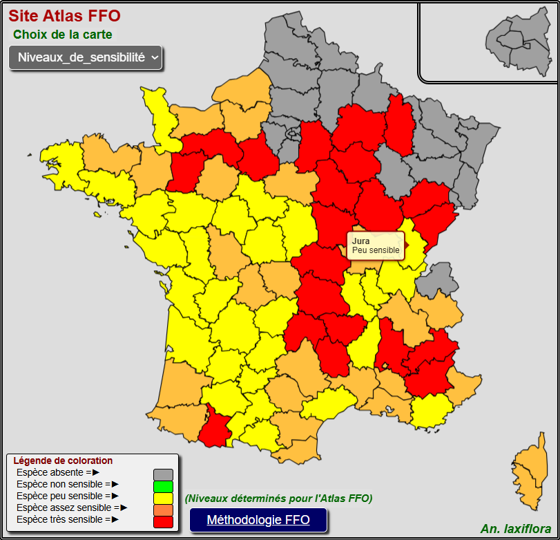
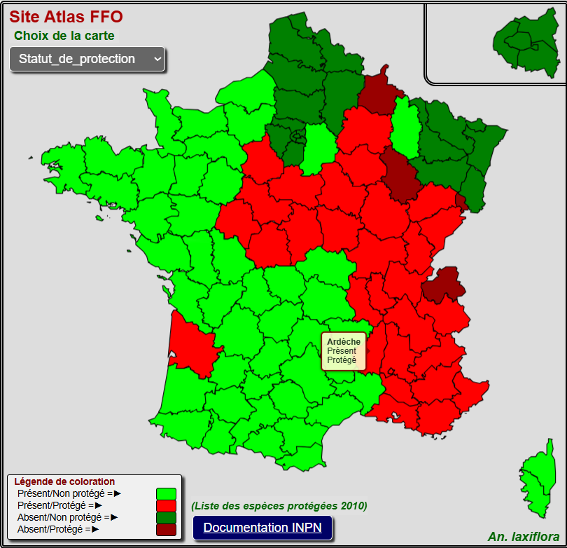
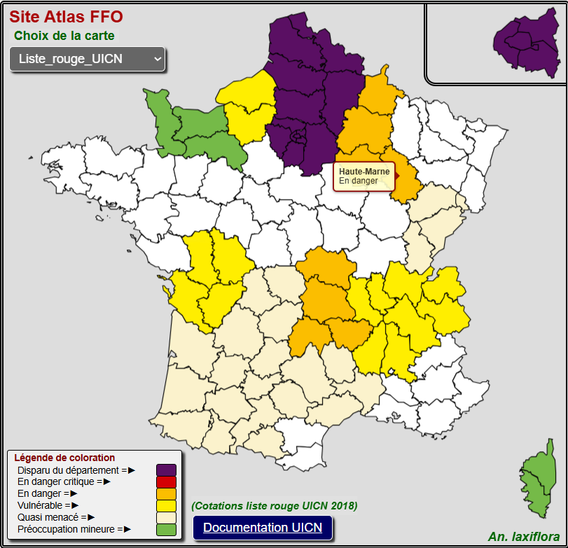
Examples for Anacamptis laxiflora (Loose-flowered Orchid)
National distribution map (10-km grid; zoomable and movable)
Distribution map by department (number of localities per department; one locality corresponds to a 250 × 250 m grid cell)
Sensitivity map by department (based on the methodology used for the FFO Atlas)
Protection status map (MNHN/INPN)
IUCN Red List map
The FFO hopes you enjoy exploring these new features on Orchisauvage and wishes you successful field surveys in 2026.
Jacques BRY, FFO Co-Administrator of the Orchisauvage website
The Fédération France Orchidées is pleased to announce the launch of the Digital Atlas of Orchids in France.
You may search by municipality (or départment or region) or by species, to view the distribution of orchids near you or during your travels, anywhere in mainland France.
Features of this Atlas are open to all, with a few extra perks reserved for FFO cartographers.
A new "FFO Digital Atlas" section has been added to the left menu, giving direct access from Orchisauvage.
Examples:
Distribution map by municipality, listing all species
(detail of Himantoglossum hircinum in Contigny, in Allier département):
2.Distribution map by species and geographical area
(Ophrys apifera in Die municipality, in Drôme département):
Thank you all for your contributions to the Atlas!
A yearly update of the Atlas data is planned.
Please continue to contribute to our collective knowledge by entering your observation data in www.orchisauvage.fr, or in the NaturaList app on your smartphone.
posted by Jacques Bry
Monday, January 6th, 2025
The site will soon have a new look and our wishes for the New Year
Dear contributors
Fédération France Orchidées, the Orchisauvage administrators Jean-Michel HERVOUET (President), Jacques BRY (cartography coordinator), Françoise PEYRISSAT (editor), Pierre-Michel BLAIS (mail contact management), and the team of cartography and validation experts, wish you all the very best for the New Year and hope that you will be able to continue sharing your discoveries here.
Orchisauvage celebrated its 10th anniversary last year. 2024 was very fruitful, with 160 000 new records (the previous record was 153 000 in 2021), bringing the total number of records to over 1.3 million. 547 new contributors (roughly equivalent to the annual mean) brought the total membership to 6 880.
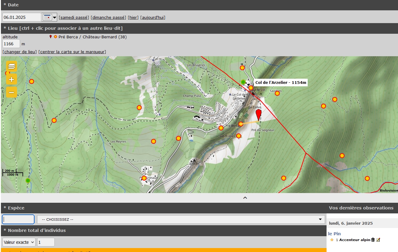
2025 will be a year of change, with a modernised look-and-feel to be implemented in the first quarter. A major change in functionality, which users of Faune-France.org will already have seen, is the introduction of localities (« lieux-dits »), which are predetermined local geographical zones, each with a name and a geo-referenced centroid position. These locality names will be visible and recorded from the start of data-entry and will be shown by your queries.
The new place names will appear on the map in all three data entry modes: click on map, GPS positioning (currently shown below the map) and choice of a municipality (commune). In the latter case there will be two possibilities, ZOOM to commune which shows the municipality and its place names, and DISPLAY which gives a list of place names.
Once you have positioned your record on the map from one of these three data entry modes you can of course reposition your record; this may modify the record’s attachment to a place name or municipality.
We are well aware that you will need a little time to get to know the new data entry methods and fully appreciate their advantages - and we will keep you informed with more details as and when the changes are implemented.
An important result of these changes - except for sensitive records and species - is that your records and those of other contributors will be visible at the centroid of each locality, and therefore more precisely than the current positions at the centroid of a municipality.
A sample of the new data entry screen is shown below (yellow dots represent the different place names defined in the system).
posted by Jacques Bry
Monday, June 10th, 2024
NaturaList user guide
A new document "NaturaList user guide" has been added in the section "How to use the site", including a description of the new entering mode "Saisie en mode liste" which is very efficient when you have a lot of observations to enter. Many thanks to the author Françoise Peyrissat.
posted by Jacques Bry
Saturday, June 17th, 2023
You can now consult the species factsheets when you enter your observations.
We recently announced that the Species factsheets were now available. Today you may notice that, to help identify the species, a new function enables you to consult each of these factsheets when you enter your observation.
Just click the « i »-labelled green button and the corresponding factsheet will open, allowing you to consult the species description and photos as well as similar species and existing hybrids.
When you want to return to your entry form, select the cross on the top right corner and validate or modify your observation if necessary.
The Orchisauvage team wishes you all the best for your botanical season in 2023
posted by Jacques Bry
Wednesday, June 7th, 2023
Our wild orchid information pages are now available online!
You can now access more than 170 reference pages about wild orchids in the Fiches espèces section (French language menu).
At the moment, they are only available in French but we are hoping being able, next year, to offer English pages as well.
Follow the table of contents and discover:
- A small photo gallery
- Precise information about each species (size, colour, morphological characteristics, flowering dates, habitat)
- Links to all the hybrids that have been observed, with thumbnail photos of the two parent plants
In some factsheets you will also find:
- A comparative table showing distinctive characteristics between related taxa
- One or two additional photos or composite images comparing closely related taxa
- A list of related taxa with direct links to their own factsheets
All the botanical terms – around 120 key words - used in the descriptions are linked to an easily-accessible glossary explaining them, often with supporting images.
Some pages are still under construction and will be added progressively.
As our main objective is to help with the identification of the plants you observe, we are planning to implement a direct access to the species factsheets when you enter your observations. We will keep you updated with these developments.
The Orchisauvage team wishes you all the best for your botanical season in 2023.
posted by Jacques Bry
Thursday, March 16th, 2023
Minimum quotas removal
Till now registered users were required to enter at least two contributions every month in order to access all the site data when using the search engine. Following March 11, 2023 decision of the Fédération France Orchidées Board of Directors who wanted a more user-friendly experience, this requirement is now no longer necessary.
The Orchisauvage administrative team hopes that the forthcoming orchid season will bring you many observation opportunities and that you will benefit from this new feature.
posted by Jacques Bry
Sunday, July 24th, 2022
The million of observation data
Orchisauvage has just passed the milestone of one million data!
The success hoped for when the site was first launched in 2014 has been achieved.
Behind this impressive amount of data, some 5 000 users - beginners or more experienced orchidophiles, alone in the field or with a group - have registered and share their observations on the site or with the NaturaList application.
More than 60 cartographers / validation experts, voluntarily examine the data, often on a daily basis, and validate them or dialogue with observers if necessary.
The objective of the site remains more than ever a better knowledge of orchids for everyone including the scientific community. Once validated, the data is used in studies, publications and naturalist inventories.
The new encyclopaedia to be published in early 2023 will contain species distribution maps produced using all the data gathered.
ORCHISAUVAGE: a tremendous collective momentum of which you are the source and for which we warmly thank you!
The site administrators on behalf of the FFO
posted by Jacques Bry
Saturday, July 9th, 2022
Collaborate to the new Encyclopaedia
Dear contributors,
This year the FFO will complete the production of a new encyclopaedic reference work on the orchids of France, Belgium and Luxembourg, with a view to publication in the 1st quarter of 2023.
This book will feature all the species distribution maps compiled from observation data that you have entered in Orchisauvage.
In order to include the most recent data, we invite you to enter them as soon as possible before the deadline of September 15, thus giving us enough time for their verification.
The Orchisauvage administrators, on behalf of the cartographers’ community, thank you in advance for taking this specific constraint into account.
Our goal is to publish maps showing the species’ history and abundance as can be seen in the example below:
posted by Jacques Bry
Monday, June 20th, 2022
A new publication : "Les orchidées sauvages des Bouches-du-Rhône"
En collaboration avec le Conseil Départemental des Bouches-du-Rhône, le cartographe départemental (Robin Rolland) a publié un nouvel ouvrage, que vous pouvez télécharger soit depuis le site de la SFO PACA soit sur le site du Conseil Départemental.